Wednesday, February 27, 2013

Life in the silver mines

Cerro Rico

The "rich mountain" and its tremendous silver supply once made Potosí the richest city in South America. Although it can no longer claim the same wealth, Potosí remains one of the highest cities in the world. While the altitude makes it difficult to get oxygen at times, it´s the dilapidated buses and horrid exhaust fumes from the abundance of non eco-friendly traffic that really made walking the streets terrible for the duration of our stay.  


Bearing Gifts

Before commencing our tour of the famous mines, we stopped at a local shop to pick up a few of the bare essentials. The three items that the miners would appreciate the most included coca leaves, moonshine and of course dynamite. Coca leaves were not only obligatory for those entering the mines, but are also a form of currency in these parts. A lady that was toiling outside the mine was ecstatic to receive her own bag.    


Mineros en la zona verde


After a lot of hunched over walking and some crawling we made it into the green zone. This little refuge is where the miners convene to chew coca leaves, drink moonshine and insult each other during their breaks and downtime. We made sure to add a fresh handful of leaves to our growing wads. Coca helps to battle fatigue and hunger and  prevents altitude sickness.    


El Tío


After ascending a chain of three rickety ladders we were surprised at what we found in the next refuge. "El Tío" rules the underworld and we had entered his lair. The miners are a superstitious group so asking to be blessed with good luck and making offerings to the demon of the mines is a way of life. Part of the group paid homage to "El Tío" by swilling 96% grain alcohol. Our guide, Pedro, who is an ex-miner took numerous hauls off the plastic bottle, eventually going slightly cross-eyed.  


Copper Sulphate
Our uncomfortable journey continued down another narrow shaft. We trudged through mud and murky waters, carefully picked our way around unmarked pits and did our best to avoid contact with the toxic substances that surrounded us. Colorful copper and silver sulphate formations that hung in our path had to be dodged along the way. At one moment, I was forced to wiggle through a small opening on my belly just to continue on.


Mine Shaft


After an eye-opening experience and the equivalent of a ninety minute walk under a kitchen table we were relieved to finally see the light of day again. The last few steps of our exit point was by far the most comfortable for walking. The working conditions on the inside are nothing short of horrendous.


Los Mineros

Tuesday, February 26, 2013

Backcountry to the Salt Flats

Bolivian Backcountry

The commitment was to jump into a 4x4 Toyota Landcruiser for a four day tour of southwestern Bolivia. We had a driver/guide, a cook and two other unknown individuals to share the experience with. We gave it some thought and figured that being in Bolivia and not visiting the world´s largest salt flat would be stupid so we signed up. Lagoons, mountains, volcanoes, ruins and geysers would help us pass the time on our way to the famous Salar de Uyuni. A surprise came in the form of the mystery twosome that would complete the group. A week earlier in Salta, we met Darko and Lijia. The couple from New Zealand, by way of Croatia and Peru reappeared at the perfect moment and joined the tour. Day one started with a late departure due to a fuel shortage at the tanks but once on the road things started looking up. Rene, our guide and driver had ten years of experience and Maria, our personal cook, wasted little time rolling out our first delicious meal.     


Géiser Sol de mañana


We spent our first night at San Antonio de Lipez. After a fitful and breathless sleep at 4,200 m. in a basic shelter (sin luz), we started day two at the early hour of 5 a.m. Cindy battled a touch of altitude sickness as we passed through a maze of ruins, mountains, volcanoes and colorful lagoons on our way to visit the geysers at more than 5000 m.    


Flamenco de Laguna Colorada


Before sitting down to our afternoon maté in Huaylljara, we visited Laguna Colorada. This beautiful lagoon is a stunning salmon red color and boasts three species of flamingos. Herds of llamas and vicuñas, viscachas and the endangered suris, which are similar in appearance to the ostrich,  made up the rest of our Bolivian safari.   


Árbol de Piedra


At 6:30 a.m. we got the call. Maria spoiled us with a delicious pancake breakfast to start day three. We stopped to take pictures at the "Tree of Stone" and climbed some of the interesting rock formations that surround it. Cindy had returned to good health and everyone was in high spirits despite the bumpy roads and dusty jeep.


Bolivianas


The rough road resulted in a few stops along the way for vehicle maintenance. We had an extended opportunity to look around the town of San Cristobal while Rene worked on a broken tie rod. After spending a few days in the remote backcountry of Eduardo Avaroa National Reserve, snacks, drinks and ice-cream availability helped make our brief stop a pleasant one.  


Indiana Jones


Cementerio de Trenes was the last scheduled tour stop for the day. After changing a flat on our unit, we spent some time exploring the array of old trains in their final resting place.  


Foto loca

We got up before sunrise, assembled our group and sped out to the salt flats in total darkness. Initially we were driving slowly through knee deep water but as the water level decreased our speed increased. As the sun rose, we were surrounded by the vast salt flat and busy taking "fotos locas". At nearly 11,000 square kilometers, Salar de Uyuni is certainly unique and standing on it is surreal.     


Salar de Uyuni

Monday, February 25, 2013

Butch Cassidy and the Sundance Kid

Red Dead Redemption

Entering Bolivia was more than crossing an imaginary line. The difference from one side of the border to the other was much more dramatic than we had imagined. The predominant color of the streets and the buildings that lined them was a muddy brown. Brightly dressed ladies in bowler hats were setting up shop to sell goods. A certain element of additional craziness was evident in the streets despite the early hour. We trudged towards the bus terminal, taking in the stunning contrast of color, style and language along the way. From the terminal we negotiated a rate for a colectivo ride to Tupiza and left the border town of Villazon. Within minutes we were on our way to  “La Joya de Bolivia”.   


Vaquera

Cindy finally got her wish. A trail ride in a wild west setting. As always, the primary concern with horseback riding in a foreign country is the health of the horses. After being pleasantly surprised with the condition of our mounts we rode out into a string of valleys not far from the final robbery site of the famous duo, Butch Cassidy and the Sundance Kid. 


Puerta del Diablo


Secondary considerations that came after mounting up included getting hit by a maniac behind the wheel of a 4x4 on our way to the trail head or getting bucked off a cliff. Cindy´s horse, Tabaco, was especially docile which helped make the ride more comfortable for both of us. After enduring a few precarious positions we arrived at the "Devil´s Door". 


Vaqueros enamorados


As the horses had a much deserved rest and drink from a fresh water stream, Cindy and I scrambled up "El Cañon del Inca" to have a better look around and enjoy some time out of the saddle. 


Valle de Los Machos


Our return trip took us through "Valle de los Machos". We enjoyed every minute of this scenic ride as any fan of the wild west era would. I continually scanned the rugged slopes for movement but the ambush never came.  

Saturday, February 23, 2013

Getting to Bolivia

Ruta 307

Returning the car to the agency in Tucumán proved to be yet another adventure. We rolled out of "Cactus Jacques" under the cover of darkness in the early hours of the morning. Heavy rains had flooded the road in several locations to add intrigue to our trip and since the car was due back the moment before the start of a national holiday we had little margin for error. We put the Gol through a final set of paces in what ended up being a four hour time trial pin to pin from Cafayate to Tucumán. We arrived with ten seconds to spare, casually returned the keys and made small talk to distract the inspector. Soon after we hopped on a bus for Salta.         


Locro and empanada lunch


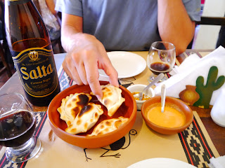
Locro, empanadas and beer was the staple for our final days in Argentina. Locro is a hearty meat based soup that is a meal in itself.   


Teleférico de Salta


Salta is a city "without sugar and without salt." However, the stop did allow us to plan our trip through Jujuy and into Bolivia.   


Quebrada de Humahuaca


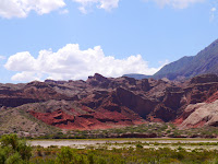
From Salta, we made our way north into the province of Jujuy. Humahuaca would be our final stop in Argentina. The small town is beautifully situated, surrounded by the colorful rock formations of the Quebrada de Humahuaca.  


Noche de Carnaval


Carnaval at Humahuaca was in full swing during our visit. Traditional dance and foam fights were the most popular activities. Following our night out and after an early morning debacle at the terminal, we did finally manage to catch a bus and travel 162 km to the border town of La Quiaca.   


Welcome to Bolivia


Crossing into Bolivia was a breeze. Our early arrival resulted in a relatively clear path through customs. After a thirty minute wait and a single document we said "adios" to Argentina and "hola" to Bolivia.  

Saturday, February 16, 2013

Dakar Rally Route


Conquering La Cuesta

Day three arrived quickly and we returned to the road. We peeled out of Coronel Moldes eager to catch a glimpse of the famous Cuesta del Obispo. Route 33 took us directly through the famous mountain pass to Piedra del Molino at 3348 meters and gave us much more than just a glimpse.  It was a hair-raising trip on the narrow road. The good stretch of pavement turned to a mix of pavement and gravel where detours had been constructed after the paved sections had slid off the cliffs they were perched on. Soon after it was all gravel for the remainder of the steep ascent. We hugged the rock face as we wound around countless blind corners and switchbacks. 


El Rey de Rally


We found a rare roadside turnout during the ascent. I was in dire need of a pit stop and Cindy was happy to get some photos outside of the moving vehicle. It was a rewarding view and we enjoyed it until we noticed some other vehicles advancing that we didn´t want to be behind. We pointed our rig uphill to complete the last leg of the pass.


Cuesta del Obispo


Route 33


After clearing “La Cuesta” everything changed. With the green valley behind us, we found ourselves on a plateau. Flat, dry and brown with nothing but cacti for miles, a straight road and another glaring example of Argentina´s diversity.  


Parque Nacional Los Cardones


With a good stretch of road ahead of us, we put the pedal down to make up some ground. That is until we pulled over again, unable to resist a stop at Parque Nacional Los Cordones. We marveled at the giant cacti and amazing scenery before continuing on to the town of Cachi.


Dakar Rally Team

Arriving in Cachi meant a couple of things. Firstly, that we would be able to see and spend a little time in the nice adobe village that we had read about and secondly, that we had to make a decision. We had a hotel booked in Cafayate and I was hell-bent not to let the deposit go to waste. Option one was to try our luck on the unforgiving stretch of road that separates Cachi from Cafayate. This section of Route 40 had been used by the Dakar Rally just a few weeks earlier. It was also the strip of road that was scribbled off the map by the boss at the rental agency as he handed us the keys. He told us not to take this route under any circumstances. “It´s not safe and not passable in a car. It is definitely a bad idea during the rainy season. Muy peligroso.”  162 km and five hours. Option two was to return the way we had come. Traverse the plateau, enter Cuesta del Obispo from a downward angle, and cruise back down past the “Devil´s Throat” all while dodging the free range llamas and goats. 271 km and six hours. 


"Echandole peligro" 
The unknown versus the known, the big risk versus  the lesser risk. Of course we asked around if this route was passable in a Volkswagen Gol (not a Golf, a 1.3 L Gol). We asked a lady at tourist info., a gas jockey, and a park ranger. “Hmmm. Si es posible. Es transitable ahora, pero tranquilo.” I figured the guy at the rental agency wanted to protect his investment and that the locals would know better, so we elected to go with our original plan and complete the loop. 


Hairpin left. Sixty.
Moments later, we were picking our way around small boulders on the road and seeing evidence of recent rock slides that had been cleared away. The occasional worrying rattle or thunk off the undercarriage or body would temporarily disrupt our conversation but we pressed on. We sped through a couple of mud bogs that I wasn´t completely sure I could get through a second time or from the other direction. The road then opened up and all was well, at least for a while. It was a nice, wide gravel road and I began to think that maybe we were in the clear. Foolish thoughts, considering we were only two hours into a five hour drive. I began thinking about rally car and drifted around the odd corner as we raced daylight and the ominous dark clouds that were moving in. The one thing I understood very well from everyone is that a heavy rain would put an end to our fun in a hurry.


Surviving Route 40
The scenery was beautiful and once again very different from the other routes. We passed through a few isolated adobe villages as we gained ground. Cindy enjoyed the passing landscape despite having a firm grip on the safety handle for some of the time, while I had to focus on the road for the most part. We scooped up a hitch hiker at Angastaco as his friend had no reason to take him further if he could catch a ride into Cafayate. They both assured us that the road ahead was good and that they had travelled it a day earlier. We were 40 km from pavement when the big drops started hitting the windshield.  A few minutes later we rolled up behind the first stream. There was a strong current and knee deep water. The local suggested that we wait a bit and sure enough the flow lessened and it was crossable. At the second crossing there were already several vehicles parked and waiting. We waited once again and squirmed across the muddy water with a little more difficulty but we continued on our way. At this point we lost our guide when his friend arrived in a truck after hearing about the road. They wished us luck and continued on. Moments later we were behind another line of cars. This time things looked really grim. Several 4x4 equipped with snorkels were making u-turns and heading back past us with the drivers shaking their heads. We proceeded forward to have a better look at the situation. The river was twenty-five meters across minimum with varying depths. A portion of the crossing looked reasonable and gave us some hope but close to the other bank it looked more complicated. There was no turning back at this point so we rolled the dice. I pointed the car upstream and eased into the water. We made the first sandbar and made a turn downstream, weaving and guessing our way around the deep sections. The car dropped hard as expected and I stomped on the gas. The tires grabbed the bank and miraculously drug us clear of the water. Jubilation! A couple of lesser streams and some hard knocks on the rental later and the tires were back on the pavement. We survived Route 40.

Friday, February 15, 2013

Quebrada de las Conchas


Los Castillos


El Obelisco


After Quilmes came Cafayate. We made a brief stop there to top up the gas tank and grab a map before pushing on. Within a few minutes of being on National Route 68 we were surrounded by stunning rock formations. "Los Castillos" and "El Obelisco" were only two of our multiple stops along this stretch of road.


Easily agitated llama


We came across this ornery llama on the edge of the road. We encountered several groups of free range goats and llamas and although they seemed fairly road wise and aware of the traffic, they had me covering the brake for much of the drive.       


The Amphitheatre


One of the most popular formations along this road is the "Amphitheatre". The acoustics are phenomenal and were on full display during our visit. A small band was playing inside the unique venue when we arrived.      


Inside the Amphitheatre


The Devil´s Throat


Just around the corner lies the "Devil´s Throat", which is the crown jewel of La Quebrada de las Conchas. We made the technical climb as far as we were permitted to do so for safety reasons. During our ascent we met a few other brave souls exploring the gorge. Some of which were using some unorthodox techniques for the descent. We cringed as one lady opted to slide down a jagged rock face on her rear end. It was no where near a flawless dismount.    


Gates of Hell


Wednesday, February 13, 2013

Road Trip Northwest Argentina

Casa de Gobierno, Tucumán

We said "adios" to Jeremy after spending seventeen action-packed days together in Chile and elected to return to Argentina to explore the northwest. Our first step was taking a night bus from Santiago to Mendoza. I was pulled off the bus at the border to pay the surprise fee of $75 to enter the country. Having a credit card allowed me the convenience of not being sent back to Chile. We arrived in Mendoza in the early morning and boarded a second bus to San Miguel de Tucumán. The bus broke down somewhere in between Mendoza and La Rioja, which extended our journey to about twenty-six hours and eventually resulted in a midnight arrival. A la Gurda hostel in Tucumán served as our headquarters for the next three days as we prepared our gear and planned a route. The city itself is pleasant and the downtown is vibrant, but only after 9 p.m. when it cools down enough to allow people to exit their sweat boxes.


Cardones y Montañas


We decided that the best way to see the remote areas that interested us the most was to rent a car. We guessed our way out of most of the city and managed to exit Tucumán unscathed. The infrequent signs are frequently incorrect.      


Llamas de Tafí del Valle


Once outside the city, we exited onto route 307 and began winding through dense jungle at low speeds. We finally emerged from the thick vegetation and passed through the small town of Tafi del Valle shortly after. Tafi seems like timezones away from jungle country, but lies just a few kilometers down the road.     


Museo de la Pachamama

After numerous gentle switchbacks along the green slopes that took us up from Tafi to an elevation of 3040 metres we descended into Amaicha del Valle. The doors to the Pachamama Museum were open, so we stopped to look at the exhibits which include a large model of the Calchaguies Valleys and many interesting artifacts. After touring the museum we headed into town in search of lodging.   


Iconografía Calchaquí
We quickly discovered that the festival of the Pachamama was kicking off and Amaicha was playing host. The town centre was barricaded and  "hospedaje" availability was scarce. However, we did find an interesting little place near the plaza that offered a place to park behind a gate and a simple room. Our "rustic" accommodations meant brandishing the silk sheet and tropical sleeping bag. In turn, our meal at the festival was barely edible but it filled the void. 


Ruinas de Quilmes


The following day started early with a trip up the road to the nearby "Ruinas de Quilmes". The sprawling ruins and overall setting is quite amazing. We spent a few hours hiking up to the various look-outs and chatting with a fellow Canadian who happened along on a motorcycle.